Short answer: The Banana River Aquatic Preserve is a 30,000 acre state preserve in Brevard County, designated in 1970, a shallow estuarine lagoon reached from U.S. Highway A1A and State Road 3. Florida law bars new dredging and filling except for listed permitted uses and bans oil wells there, seagrass damage can bring a $1,000 fine, and federal manatee refuges set slow speed in parts of it. City parks in Cape Canaveral give shore views.
Last verified: October 21, 2026, against the sources listed at the end of this page.
What is the Banana River Aquatic Preserve?
The Banana River Aquatic Preserve is a 30,000 acre piece of the Indian River Lagoon in Brevard County that Florida's Board of Trustees designated in 1970 and state law now protects as an aquatic preserve.
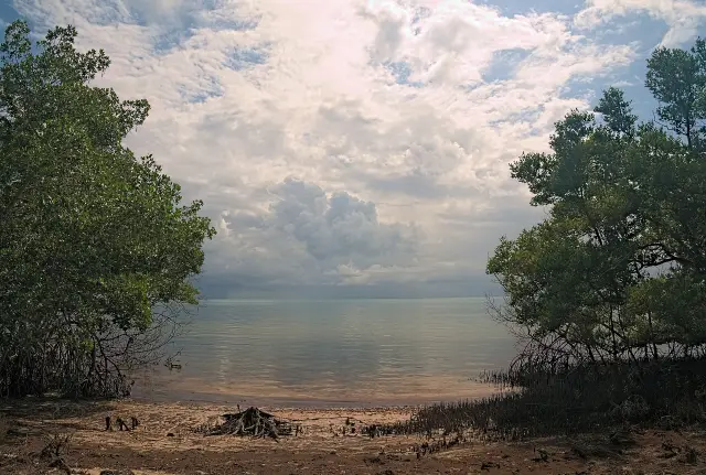
FDEP's area information lists the preserve's county as Brevard, its acreage as 30,000 and its type as a long, wide and shallow estuarine lagoon, fed by fresh water from rivers and creeks and salt water from the ocean (FDEP preserve page). The Board of Trustees officially designated it in 1970, and it was folded into the broader Aquatic Preserves Act of 1975. FDEP manages it as one of four key components of the Indian River Lagoon Aquatic Preserves system, and the habitat types FDEP lists for it include Outstanding Florida Waters, mangrove islands, mollusk reef and spoil islands.
The legal purpose behind the Banana River designation is written into statute. The Legislature declared that state-owned submerged lands of exceptional biological, aesthetic and scientific value be set aside forever as aquatic preserves or sanctuaries for the benefit of future generations (s. 258.36, Florida Statutes).
Where does the Banana River Aquatic Preserve begin and end?
State law fixes the preserve by a recorded legal description in Brevard County's Official Records plus a statutory boundary that pulls in Newfound Harbor and Sykes Creek.
Section 258.39(6) defines the Banana River Aquatic Preserve as the area described in the Official Records of Brevard County in Book 1143, pages 195-198, and the sovereignty submerged lands inside a boundary that runs along the ordinary high water lines of Newfound Harbor and Sykes Creek north to the southerly right-of-way of Hall Road (s. 258.39, Florida Statutes). The statute does not restate the recorded description itself.
On the ground, FDEP lists U.S. Highway A1A and State Road 3 as the road access, names a network of ramps, launches and open shoreline for the public, and leaves parking to local regulations (FDEP preserve page). Cocoa Beach's management plan for the Thousand Islands, revised in December 2008, describes the waters around that city conservation site as Class III waters of an Aquatic Preserve, inside the Indian River Lagoon SWIM program and National Estuary Program boundaries (Cocoa Beach Thousand Islands plan).
FDEP's geology note explains what lies beneath the Banana River. The preserve sits on the Atlantic Coastal Ridge, and its western shore is characterized by the Anastasia Formation, a fossil-rich limestone formed over 5.3 million years ago (FDEP preserve page).
What wildlife lives in the Banana River Aquatic Preserve?
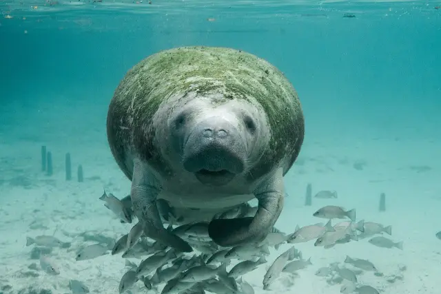
FDEP lists bottlenose dolphins, West Indian manatees, diamondback terrapins, brown pelicans and game fish such as redfish, snook and tarpon among the Banana River preserve's residents.
| Group | Species named | Source |
|---|---|---|
| Mammals | Atlantic bottlenose dolphin, West Indian manatee | FDEP |
| Reptiles | Alligators, diamondback terrapins | FDEP |
| Fish | Redfish, black drum, tarpon, snook, mullet | FDEP |
| Birds | Wading birds, seabirds, shorebirds | FDEP |
| Invertebrates | Oysters, horseshoe crabs, seahorses | FDEP |
| Plants | Seagrasses; red, black and white mangroves | FDEP |
FDEP calls the Banana River essential habitat for the West Indian manatee and pelicans in particular, along with other nesting and migrating birds and turtles, across mangrove swamps, tidal mud flats and sandy shorelines (FDEP preserve page). FDEP names Honeymoon East and Honeymoon West as the two spoil islands in this preserve where brown pelicans nest. Spoil islands in general were built from dredge material during construction of the Intracoastal Waterway; FDEP says much of their vegetation is exotic Brazilian pepper and Australian pine, yet most of the bird rookeries in the lagoon's aquatic preserve system are now on spoil islands.
On the Cocoa Beach side, the Thousand Islands plan places that site within a Strategic Habitat Conservation Area for listed wading birds (Cocoa Beach Thousand Islands plan).
What does Florida law forbid in the Banana River Aquatic Preserve?
Inside the Banana River preserve, Florida law bars new dredging and filling except for listed permitted purposes, bans oil and gas wells and mineral mining, and limits sales and leases of the bottom to the public interest.
For the Banana River, as for every Florida aquatic preserve, section 258.42 tells the trustees that no further sale, lease or transfer of sovereignty submerged lands may be approved unless it is in the public interest, while aquaculture leases may be authorized (s. 258.42, Florida Statutes). No further dredging or filling may be approved except by permit for minimum dredging for public navigation, marinas, piers and docks, maintenance of existing channels, public utility work and similar listed needs. There shall be no drilling of gas or oil wells, and no excavation of minerals except the dredging of dead oyster shells approved by DEP. Structures are limited too; private residential docks may be approved for reasonable ingress and egress of riparian owners.
For boaters on the Banana River, the rule FDEP stresses is seagrass. Its FAQ says seagrass is protected within aquatic preserves, that boats should avoid shallow water and raise the motor over seagrass, and that damage to seagrass can bring a fine up to $1,000 (FDEP preserve page). FDEP also asks visitors to follow FWC's saltwater fishing and boating regulations and to keep pets on leash near conservation areas.
Which manatee rules apply on the Banana River?
Two federal manatee refuges cover waters tied to the preserve, the Barge Canal refuge with its marked Banana River channel and the Sykes Creek refuge, and both require slow speed all year.
Under 50 CFR 17.108, the Barge Canal Manatee Refuge covers all waters within the banks of the Barge Canal plus the marked channel in the Banana River between the canal's east entrance and the Canaveral Locks, about 682.7 acres, and the Sykes Creek Manatee Refuge covers Sykes Creek south of the S curve and north of the Sykes Creek Parkway, about 845.8 acres (50 CFR 17.108). In each, watercraft must proceed at slow speed, channel included, all year. Sykes Creek is also one of the waters the state statute names inside the preserve boundary (s. 258.39).
On the barrier island, the City of Cape Canaveral says Manatee Sanctuary Park takes its name from sitting next to a stretch of the Banana River that is protected manatee habitat, while warning that it cannot guarantee sightings (Cape Canaveral parks page). The city's parks page and FDEP give the same number for an injured animal: FWC at 1-888-404-FWCC (3922) (FDEP preserve page).
Where can the public see the Banana River from Cape Canaveral, Cocoa Beach and Satellite Beach?
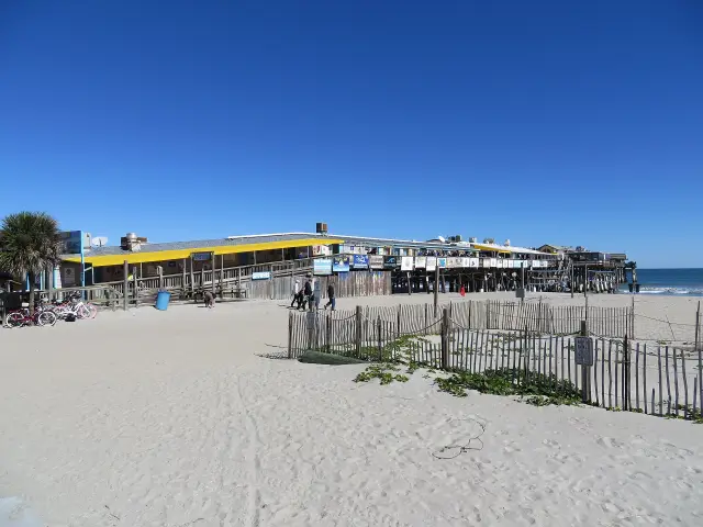
City parks in Cape Canaveral overlook the river, Ramp Road Park in Cocoa Beach is the boat ramp FDEP names, and Satellite Beach runs free monthly boat trips to its Samsons Island Nature Park, a lagoon spoil island.
| Place | City | What the source says | Source |
|---|---|---|---|
| Center Street Park, 7108 Center Street | Cape Canaveral | Gazebo with seating overlooking the Banana River, west end of Center Street | City parks page |
| Manatee Sanctuary Park, 701 Thurm Boulevard | Cape Canaveral | Borders protected manatee habitat on the river | City parks page |
| Ramp Road Park boat ramp | Cocoa Beach | Boat ramp FDEP lists for the preserve; the city lists the park at 401 Ramp Road among its parks with lagoon access | FDEP; Cocoa Beach parking page |
| Samsons Island Nature Park | Satellite Beach | Indian River Lagoon spoil island reached only by water; public docks on north, east and south sides | City of Satellite Beach |
Satellite Beach, which FDEP lists among the preserve's partner groups (FDEP preserve page), offers free monthly eco tours with the boat ride included; the city page sets the departure for 9:00 AM on the first Sunday of each month from its fire department, with guests back by 12:00 PM, and says space is limited, reservations are required, and the Recreation Department answers questions at 321-773-6458 (Samsons Island page). The city says volunteers began clearing exotic plants and adding native vegetation, picnic areas and grills there in the early 1990s. The city page places Samsons Island in the Indian River Lagoon and does not name the Banana River.
FDEP charges no fee to visit the Banana River preserve. Asked about guided tours, FDEP's FAQ answers only that many private vendors around the lagoon offer them (FDEP preserve page). FDEP also notes that ADA access depends on the specific access point and its managing entity, so each park's own managing city is the place to ask.
Who manages the Banana River Aquatic Preserve, and how can residents help?
FDEP's Indian River Lagoon Aquatic Preserves office manages the Banana River under a system plan first written in 1985 and significantly updated in 2017, and it takes volunteers through [email protected].
FDEP lists its conservation work in the Banana River preserve as protecting bird nesting areas, planting mangroves, restoring oyster reefs and surveying seagrass, with ongoing research on shorebird and seabird nesting and on oysters (FDEP preserve page). Volunteer work includes beach and spoil island cleanups, and the preserve's public contact line is 772-448-5930.
Local governments on the shoreline add their own projects. Cocoa Beach's Thousand Islands plan describes a city canal dredging program that removes decades-old urban muck from the canals so the sediment does not reach the lagoon's seagrass beds, supported by the Indian River Lagoon National Estuary Program, and it records that state CARL purchases in the late 1980s bought privately owned land in the northern Thousand Islands (Cocoa Beach Thousand Islands plan). The best time to visit, by FDEP's figures, depends on heat and rain: average summer temperatures run 72 to 91 degrees and winter 48 to 70, and roughly 62% of the lagoon's 55 to 60 inches of yearly rain falls June through October (FDEP preserve page).
Last verified: October 21, 2026, when FDEP's Banana River preserve page was fetched again together with ss. 258.36, 258.39 and 258.42, the federal manatee refuge rule, the Cape Canaveral parks list, the Samsons Island page and the Cocoa Beach Thousand Islands plan.
Frequently asked questions
How big is the Banana River Aquatic Preserve?
FDEP lists the Banana River Aquatic Preserve at 30,000 acres in Brevard County, designated in 1970.
Do dolphins and manatees live in the Banana River?
FDEP lists the Atlantic bottlenose dolphin and the West Indian manatee among the preserve's mammals, and Cape Canaveral's Manatee Sanctuary Park borders protected manatee habitat, though the city does not guarantee sightings.
Does it cost anything to visit the Banana River Aquatic Preserve?
No. FDEP says there are no fees for the preserve; parking at each access point follows local rules.
Is there a speed limit for boats on the Banana River?
Federal rules make the Barge Canal Manatee Refuge, including the marked Banana River channel to the Canaveral Locks, and the Sykes Creek Manatee Refuge slow speed all year.
Is Sykes Creek part of the Banana River Aquatic Preserve?
Yes. Section 258.39 of Florida Statutes includes the sovereignty submerged lands of Sykes Creek and Newfound Harbor north to Hall Road in the preserve.
Sources
- Banana River Aquatic Preserve, Florida Department of Environmental Protection https://floridadep.gov/rcp/aquatic-preserve/locations/banana-river-aquatic-preserve Used for: designation, acreage, access, wildlife, spoil islands, FAQ, contacts
- Florida Statutes 258.36, Legislative intent https://www.flsenate.gov/Laws/Statutes/2025/258.36 Used for: set aside forever
- Florida Statutes 258.39, Boundaries of preserves https://www.flsenate.gov/Laws/Statutes/2025/258.39 Used for: Book 1143 pages 195-198, Newfound Harbor, Sykes Creek, Hall Road
- Florida Statutes 258.42, Maintenance of preserves https://www.flsenate.gov/Laws/Statutes/2025/258.42 Used for: dredge, fill, drilling, structures
- 50 CFR 17.108, Manatee protection areas (eCFR) https://www.ecfr.gov/current/title-50/chapter-I/subchapter-B/part-17/subpart-J/section-17.108 Used for: Barge Canal and Sykes Creek manatee refuges
- Cape Canaveral Parks, City of Cape Canaveral https://www.capecanaveral.gov/quality_of_life/parks.php Used for: Center Street Park, Manatee Sanctuary Park
- Samsons Island Nature Park, City of Satellite Beach https://www.satellitebeach.gov/departments/recreation-department/parks-facilities/samsons-island-nature-park/ Used for: water-only access, eco tours
- Thousand Islands Conservation Area Management Plan, City of Cocoa Beach http://cityofcocoabeach.com/DocumentCenter/View/348/South-Thousand-Island-Conservation-Area-Management-Plan-PDF Used for: Class III waters of an aquatic preserve, CARL, canal muck dredging
- Parking Information, City of Cocoa Beach https://www.cityofcocoabeach.com/185/Parking-in-Cocoa-Beach Used for: Ramp Road Park, 401 Ramp Road, listed among parks with lagoon access
Published by Rytas Dirse, Solo Founder & AI Architect
Built with AI, held to quality gates. US sources, US brands, facts only.
How this page was made
Digital Towns uses AI assistance to research and write its guides, and every page is only as good as the sources it cites. Our goal is the most accurate, useful local information possible.
If you see an error, or anything you can show is false, tell us right away and we will take a third look.
Report an error
Thank you. We'll take a third look and correct the page if it's wrong.